Practice run
Still wet behind the ears
Saturday, September 20, 2008
Friday, September 5, 2008
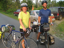
South Royalton, VT to APPLETON, MAINE!! FIN
From South Royalton we pushed on through the Green Mountains and made quick time of the rest of VT. The ride consisted largely of winding roads along side babbling creeks. It was a fragrant farm country preparing for apple season. Upon reaching the Connecticut River Valley we followed the CT River north for a few miles before crossing over to New Hampshire. A little short of our mileage goal for the day, we asked a local apple farmer for a lawn to camp on. He kindly offered up a spot beneath the monkey bars and behind the swing set. We cooked dinner to a gorgeous view of the mountains and visited with the resident goats before calling it an early night (the next morning would bring over 5000 feet of vertical climb and we wanted to be ready).
Morning on the orchard was thick. The fog enshrouding the CT River surrounded our tent, soaked our drying clothes and left little drops of condensation inside the rain fly that would trickle down on us if we moved too abruptly. Morning also brought cider donuts and blueberry pancakes. Lucky for us, the Windy Ridge Orchard sported a small cafe that fired up a griddle at 7am. They let us in at a quarter till'.
The day was grueling. The first climb took us up 2500 feet of elevation through two ascents, one a false summit. On the way, we stopped at a beaver pond along side the Appalachian Trail and admired the rocky outcroppings. We paused to take photos of streams that had carved sinuous beds out of the rock face. The clearing amidst the mixed coniferous canopy allowed for spectacular views of the surrounding summits, many of which, we learned, may have once stood over 12,000'. Glacial activity in the region wore down the great Appalachians leaving gradual slopes on the NW sides of the mountains and sharp contours to their SE.
On the first long decent, we stopped at a playful cascade and took many photos of ourselves perched atop huge boulders and tried to visualize the force that over the years had carved them into their current forms. Unfortunately, there were signs all over the place reinforcing the rule of no swimming in the cascades. It was easy to imagine how attractive the drops into cascade plunge pools would be to hormone heavy teens hoping to show off to their peers. Anna reminded Matt more than once that she wouldn't be impressed.
The next climb was known to the locals as "The Kanc"; Kancamagus Pass. It is named after the last ruler of the Pennacook Confederacy of Tribes, which populated the area until the 1690s when conflicts with European settlers forced them north to Canada. The Pennacook farmed maize, corn and squash in the fertile river beds and hunted in the vast wooded areas. Kancamagus means "The Fearless One". The 2000+ peak separates two major watersheds in the NE. The western slope drains to the Merrimack River which reaches the Atlantic at Newburyport, Massachusetts while the eastern slope drains to the Saco River, which joins the ocean at Saco, Maine. The gradual incline slowly revealed the surrounding landscape, defined by long sloping ridges and broken peaks once buried under a mile of ice.
En route, we learned about the increasing popularity of the region. Recreational users flocked to the White Mountains in the early 1800's for hiking, snowshoeing, skiing and horse packing. In the 1900's, the Society for the Protection of New Hampshire Forests began the movement to protect the White Mountains. By 1911, Congress passed the Weeks Act which created the White Mountains National Forest. The following half century brought much delegation over decision making whether or not to introduce tunnels through the region, how to manage forest practices, and the publicised battle over protecting the mountain passes from four-lane highways. By the passing of the Wilderness Act in 1977, protection agencies had acquired over 77,000 acres in the White Mountains. The following two decades would add over 150,000 more.
At the top of the 'Kanc' we came across the ROMEOS (Retired Old Men Eating Out), a motorcycle group who were very interested in our trip. During our descent, each of them gave a signature wave and a stylized honk of the horn. We also stopped at an old homestead that is maintained by the Park Service about 15 miles west of Conway, in an area that was once a bustling logging town. We walked around the house which retained all of the original timbers from it's construction in the 1700s. The house had a sad story connected to it; in the late 1800s, a couple lived in the house, which at that point was one of only a few homesteads left in the area. One day the husband, Thomas Colbath, went out for an evening walk and told his wife, Ruth-Priscilla, that he would be back in a little while. Well, a little while turned out to be 40 years! She never gave up hope for his return, and placed a lantern in the window every night until she died. He did return three years after her death, but had no real explanation for where he had been or why he had left.
After a quick swim in the Swift River, which we followed all the way into Conway, NH, we arrived at our evenings accommodations with Dr. Becky Mulkern, whom we'd found through the couchsurfing.com website. It turns out that her son Casey is a co-founder of the website! If you haven't seen/tried it, it is a really amazing way to travel and meet people from around the world. Becky was very kind to us, cooking us up some dinner before she had to rush to a meeting. We walked into Conway that evening and met some friendly locals at the movie theater.
The next morning it was only a short cruise to MAINE! We made our way through Fryeburg, and into the international section of Maine. We passed through Norway, Paris and Sweden all in the same day! We were excited to see the popularity of the local food movement is also in Maine, as we passed many farms and stopped at the food co-op in Norway to see local foods featured in the area's tourism magazine. After a grueling ride up an incredibly steep hill, we stopped for a snack at an apple orchard owned by Steven King's sister-in-law, a fact which we found out from some friendly folks who have a cabin in the area.
For our last night on the trip we were treated to a delicious meal and great conversation with another of Matt's aunt's childhood friends living in Buckfield, ME, Margot and Bob Siekman. The five mile detour to their house was well-worth it as we relaxed in their kitchen overlooking a hayfield and surrounding wooded hills. They sent us off in the morning with fresh waffles, covered in their own just-picked high bush blueberries.
The final day of the trip began with, wouldn't you know it, an ice cream stop. What was supposed to be a quick stop to check the map ended up with a triple-decker scoop of chocolate peanut butter cup. Fully fueled up, we carved a winding path through once-cleared wood lots and crossed our fingers that the days forecast for rain showers would let us pass unhindered. By the time we reached Richmond, ME we were still dry and enjoying lunch on the banks of the
Kennebec River. The overgrown rock walls that line all the roads, as well as the many old cemeteries, stacked firewood and fields of goldenrod were comfortingly New England. We both grew up here, and the familiar sights, sounds and smells were a great way to wind down the trip.
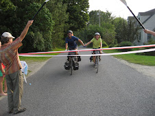
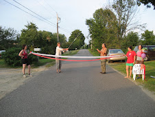
The last leg of our journey brought us to Route 1 just inland of Damariscotta. We made quick time of Route 1 as it was full of vacationers flocking all the Maine coast towns. There is a good reason Maine is known as vacationland, particularly on Labor Day weekend. Anna's Dad and sister met us on the road, and gave us a grand escort to the finish line (don't worry, it was a tie!), where friends waited to welcome us home. To see photos of the last part, click on the picture of the river, below.
Morning on the orchard was thick. The fog enshrouding the CT River surrounded our tent, soaked our drying clothes and left little drops of condensation inside the rain fly that would trickle down on us if we moved too abruptly. Morning also brought cider donuts and blueberry pancakes. Lucky for us, the Windy Ridge Orchard sported a small cafe that fired up a griddle at 7am. They let us in at a quarter till'.
The day was grueling. The first climb took us up 2500 feet of elevation through two ascents, one a false summit. On the way, we stopped at a beaver pond along side the Appalachian Trail and admired the rocky outcroppings. We paused to take photos of streams that had carved sinuous beds out of the rock face. The clearing amidst the mixed coniferous canopy allowed for spectacular views of the surrounding summits, many of which, we learned, may have once stood over 12,000'. Glacial activity in the region wore down the great Appalachians leaving gradual slopes on the NW sides of the mountains and sharp contours to their SE.
On the first long decent, we stopped at a playful cascade and took many photos of ourselves perched atop huge boulders and tried to visualize the force that over the years had carved them into their current forms. Unfortunately, there were signs all over the place reinforcing the rule of no swimming in the cascades. It was easy to imagine how attractive the drops into cascade plunge pools would be to hormone heavy teens hoping to show off to their peers. Anna reminded Matt more than once that she wouldn't be impressed.
The next climb was known to the locals as "The Kanc"; Kancamagus Pass. It is named after the last ruler of the Pennacook Confederacy of Tribes, which populated the area until the 1690s when conflicts with European settlers forced them north to Canada. The Pennacook farmed maize, corn and squash in the fertile river beds and hunted in the vast wooded areas. Kancamagus means "The Fearless One". The 2000+ peak separates two major watersheds in the NE. The western slope drains to the Merrimack River which reaches the Atlantic at Newburyport, Massachusetts while the eastern slope drains to the Saco River, which joins the ocean at Saco, Maine. The gradual incline slowly revealed the surrounding landscape, defined by long sloping ridges and broken peaks once buried under a mile of ice.
En route, we learned about the increasing popularity of the region. Recreational users flocked to the White Mountains in the early 1800's for hiking, snowshoeing, skiing and horse packing. In the 1900's, the Society for the Protection of New Hampshire Forests began the movement to protect the White Mountains. By 1911, Congress passed the Weeks Act which created the White Mountains National Forest. The following half century brought much delegation over decision making whether or not to introduce tunnels through the region, how to manage forest practices, and the publicised battle over protecting the mountain passes from four-lane highways. By the passing of the Wilderness Act in 1977, protection agencies had acquired over 77,000 acres in the White Mountains. The following two decades would add over 150,000 more.
At the top of the 'Kanc' we came across the ROMEOS (Retired Old Men Eating Out), a motorcycle group who were very interested in our trip. During our descent, each of them gave a signature wave and a stylized honk of the horn. We also stopped at an old homestead that is maintained by the Park Service about 15 miles west of Conway, in an area that was once a bustling logging town. We walked around the house which retained all of the original timbers from it's construction in the 1700s. The house had a sad story connected to it; in the late 1800s, a couple lived in the house, which at that point was one of only a few homesteads left in the area. One day the husband, Thomas Colbath, went out for an evening walk and told his wife, Ruth-Priscilla, that he would be back in a little while. Well, a little while turned out to be 40 years! She never gave up hope for his return, and placed a lantern in the window every night until she died. He did return three years after her death, but had no real explanation for where he had been or why he had left.
After a quick swim in the Swift River, which we followed all the way into Conway, NH, we arrived at our evenings accommodations with Dr. Becky Mulkern, whom we'd found through the couchsurfing.com website. It turns out that her son Casey is a co-founder of the website! If you haven't seen/tried it, it is a really amazing way to travel and meet people from around the world. Becky was very kind to us, cooking us up some dinner before she had to rush to a meeting. We walked into Conway that evening and met some friendly locals at the movie theater.
The next morning it was only a short cruise to MAINE! We made our way through Fryeburg, and into the international section of Maine. We passed through Norway, Paris and Sweden all in the same day! We were excited to see the popularity of the local food movement is also in Maine, as we passed many farms and stopped at the food co-op in Norway to see local foods featured in the area's tourism magazine. After a grueling ride up an incredibly steep hill, we stopped for a snack at an apple orchard owned by Steven King's sister-in-law, a fact which we found out from some friendly folks who have a cabin in the area.
For our last night on the trip we were treated to a delicious meal and great conversation with another of Matt's aunt's childhood friends living in Buckfield, ME, Margot and Bob Siekman. The five mile detour to their house was well-worth it as we relaxed in their kitchen overlooking a hayfield and surrounding wooded hills. They sent us off in the morning with fresh waffles, covered in their own just-picked high bush blueberries.
The final day of the trip began with, wouldn't you know it, an ice cream stop. What was supposed to be a quick stop to check the map ended up with a triple-decker scoop of chocolate peanut butter cup. Fully fueled up, we carved a winding path through once-cleared wood lots and crossed our fingers that the days forecast for rain showers would let us pass unhindered. By the time we reached Richmond, ME we were still dry and enjoying lunch on the banks of the
Kennebec River. The overgrown rock walls that line all the roads, as well as the many old cemeteries, stacked firewood and fields of goldenrod were comfortingly New England. We both grew up here, and the familiar sights, sounds and smells were a great way to wind down the trip.
The last leg of our journey brought us to Route 1 just inland of Damariscotta. We made quick time of Route 1 as it was full of vacationers flocking all the Maine coast towns. There is a good reason Maine is known as vacationland, particularly on Labor Day weekend. Anna's Dad and sister met us on the road, and gave us a grand escort to the finish line (don't worry, it was a tie!), where friends waited to welcome us home. To see photos of the last part, click on the picture of the river, below.
Subscribe to:
Posts (Atom)